


A pilot program meant to preserve the water quality of this premier Minnesota fishing lake starts with individual lakeshore property owners
MALMO – Waves build for 20 miles before they pound Mille Lacs’ northeast corner, where Barbara and Michael Macioch own 120 feet of sandy shoreline and a retirement home near Malmo.
The Maciochs have done what they can to curb runoff and minimize erosion since they moved in 19 years ago. They’ve tended the bank-stabilizing line of trees that screen their lake view. They’ve let deep-rooted sedges replace grass. Planted shrubs. Stopped mowing.
Lakeshore property owners like the Maciochs, who encourage neighbors to take the long view, play a pivotal role in a three-year, three-county, $337,750 pilot program meant to preserve Mille Lacs’ water quality. With a coordinator hired and money for lake-friendly landscaping available, the Compass program is poised to intensify outreach efforts this spring.
“The purpose of (the) program is to protect the water quality of the lake. A very close second is building community around the lake,” said Jason Weinerman, Waite Park-based Minnesota Board of Water and Soil Resources conservationist.
That’s where Harmony Maslowski comes in. Her job – Mille Lacs Soil & Water Conservation District watershed coordinator – includes leading the Compass program.
The Mille Lacs Lake Water Management Group, which formed in 1997 to manage the surrounding water resources, developed Compass to support and promote lakeshore property owners’ active role in protecting the lake.
Through their involvement with that group, the Maciochs have promoted stewardship among neighbors. Michael has served as chairman. Barbara has routinely distributed information to 40 friends.
“Just because we live on the lake, we feel we owe something back to the lake,” said Michael, 74. A retired 3M photographic research specialist, he and Barbara, 78, a retired 3M secretary, moved here to be close to family and fishing.
“The overall goal of our group is to maintain the water (quality) of Mille Lacs and not make it any worse. That’s part of the problem: It looks good. We don’t get a lot of weeds,” Michael Macioch said.
“It’s really imperative that this treasure, or this feature that we are living next to, that we protect it,” Barbara Macioch said.
Participation is voluntary, and starts with an SWCD technician and landowner touring the property together. The technician notes practices already in place and presents a list of potential improvements to each landowner.
Compass efforts might include managing runoff by installing rain barrels or planting native species to filter runoff, stabilize the shoreline and minimize erosion.
In-kind and landowner contributions will match BWSR’s $268,750 Clean Water Fund grant. Mille Lacs, Aitkin and Crow Wing county SWCD technicians provide landowners with free lake stewardship plans. Grant funds may pay up to 75 percent of project costs.
“All of those little projects make the big picture. Every person that you can get to put up a rain barrel or let a buffer grow or plant some trees or shrubs on their lawn – every one person that does that can influence another person,” said Lynn Gallice. A longtime conservation technician with Mille Lacs SWCD, she helped develop the Compass program, and has led walk-overs with property owners.
Janet Smude agreed with the neighbor-to-neighbor approach. The longtime Aitkin SWCD technician and former watershed coordinator, she initially handled Compass finances for the three counties.
“Every little step that we take will help to make the lake healthy,” Smude said. “It’s better to keep the lake healthy than to try to restore it after it’s lost its health.”
Over the winter, Compass is fine-tuning its approach.
Compass was developed as a tiered recognition program, much like lodging establishments’ “green” designations signaling environmentally friendly practices. Signs would indicate not only levels of involvement – bronze, silver and gold – but also people willing to help others.
“If you care, you act like you care and you’ll hopefully discuss it with your neighbors and show you care,” Michael Macioch said of the three-tiered proposal. “It proves to the world that you give a darn and that you’re actively doing something about protecting your investment.”
Landowners loved the consultations and the free lake stewardship plans aligned with water-quality goals. They didn’t want to post signs or be featured in news articles.
A revised outreach effort is planned for early spring.
“The focus is organizing active citizens and trying to inspire people to have that active role in improving and protecting the watershed,” Maslowski said. “What we’re hoping is eventually there will be the ability for it to spread along the watershed.”
Mille Lacs’ sheer size poses one challenge. At 132,500 acres – more than 200 square miles – it’s Minnesota’s second-largest inland lake.
Mille Lacs 2,878 lakeshore properties generated $5.1 million in tax capacity within the three counties in 2017. Their estimated market value exceeded $672.6 million. The 60 miles of highway encircling Mille Lacs passes Mille Lacs Band of Ojibwe tribal land, other year-round and seasonal residents, as well as resorts and businesses.
Connecting permanent and seasonal residents is another challenge.
“They both have Mille Lacs Lake as a focus that’s important to them. One aspect is seasonal, where people are coming up for recreation. (Then) you have the people who are there year-round,” Maslowski said.
Because water quality is apparently good, Michael Macioch said considering alternative landscaping may seem to vacation home owners like a waste of their limited recreational time.
“They want to do what they came up here to do, whether it’s boating or fishing, and they don’t want to take the time to do anything else because they look at their situation and think it’s good enough,” Michael Macioch said.
The Compass program strives to highlight individual landowners’ roles in lake health.
The Mille Lacs Band of Ojibwe, meanwhile, started water sampling in the early 1990s. Its long-term monitoring study began in 2005. Samples collected monthly, June through September, from 16 points around the lake are tested for chlorophyll-a, clarity and total phosphorus.
“We always keep our finger on the pulse of the lake,” said Perry Bunting, director of environmental programs for the Mille Lacs Band of Ojibwe Department of Natural Resources.
“You can’t pick up and move the reservation. This is the Mille Lacs Band’s homeland,” Bunting said. “A property owner can sell his cabin and go buy a cabin on (another lake), where the Mille Lacs Band is here for the long haul. So being good stewards … that’s just part of their nature.”
If the Compass program takes hold and more property owners take the long view, in 10 years the shoreline could have a more natural look.
“I would like people to get comfortable with less mowed lawn and a lot more trees,” Gallice said. “People’s idea of a beautiful lawn is a manicured, mowed lawn. All the things that can go into that can be bad for the lake.”
Turf grass’ short roots succumb to erosion. Runoff races across cropped lawns. Fertilizer pollutes the water.
“These are recreational areas and their homes. So you’ve got to have a place for your kids to play and a place to put your lawn chairs and a place to have a picnic. We can work with that. Absolutely. I’m never going to tell people you can’t have any,” Gallice said. “We work with people to come up with, ‘How can we have it both ways?’ – something so that they’re going to be able to enjoy their lake property, which they worked so hard for, and yet still protect the lake as much as possible.”
Ten years from now, Gallice said she would like to see a landowner-run Compass program whose experienced members can draw up basic stewardship plans independently.
The Minnesota Board of Water and Soil Resources’ mission is to improve and protect Minnesota’s water and soil resources by working in partnership with local organizations and private landowners. Website: www.bwsr.state.mn.us.
The Mille Lacs Lake Water Management Group is a partnership among lakeshore property owners; Mille Lacs, Aitkin and Crow Wing SWCDs and counties; the Mille Lacs Band of Ojibwe; townships; lake associations; and residents and businesses within the 182-square-mile watershed. Compass was developed through a Minnesota Pollution Control Agency Clean Water Partnership grant.
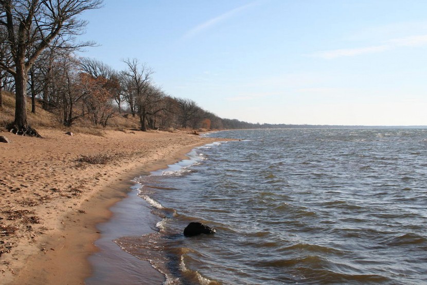
Photo: Mille Lacs’ sandy shoreline west of Malmo on the northeast corner of the lake makes combatting erosion with landscaping a challenge. Photo Credit: Mille Lacs Band of Ojibwe DNR